The following describes the eligibility restrictions for short-term rental permits.
- Short-Term Rental are prohibited:
- Within Mobile Home Parks, affordable housing units, or in apartment buildings.
- On properties containing an ADU or Junior ADU pursuant to State Law.
- On a parcel when the resulting residential “block density” goes over 20% within the Davenport/Swanton Designated Area (DASDA), Live Oak Designated Area (LODA), or Seacliff/Aptos/La Selva Beach Designated Area (SALSDA).
- A property is prohibited from having a Non-Hosted Rental Permit and a Hosted Rental Permit simultaneously.
- Only one Short-Term Rental is permitted per person/entity/property.
- Within the three Designated Areas, a parcel is prohibited from a Non-Hosted Rental permit when adjacent to two or more parcels with active Non-Hosted Rental permits. "Adjacent" means a shared parcel line or two parcels that would share a parcel line if the road or alley between them were removed.
Short-term rentals are organized by four different areas within the County
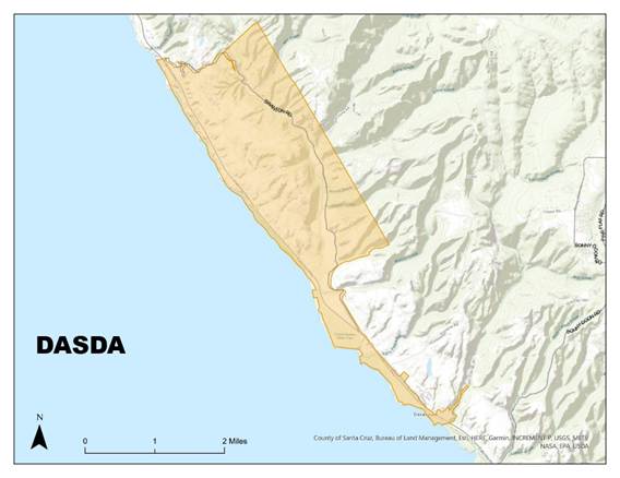
The Davenport/Swanton Designated Area (DASDA)
“Davenport/Swanton designated area” or “DASDA” means that portion of the North Coast Planning Area bounded on the south by Riverside Avenue and San Vincente Street in the unincorporated town of Davenport, and extending north along Highway 1 to include the areas of New Town and Davenport Landing south of Highway 1, and bounded on the north by the intersection of Swanton Road and Highway 1, and including all parcels within one-quarter mile of Swanton Road, but excluding any parcels that abut Last Chance Road.
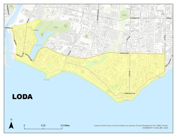
The Live Oak Designated Area (LODA) “Live Oak designated area” or “LODA” means the Harbor Area Special Community (as described in the General Plan—Local Coastal Program and depicted on the General Plan—Local Coastal Program map) and that portion of Live Oak that lies east and south of East Cliff Drive and Portola Drive from the intersection of 9th Avenue and East Cliff Drive to the intersection of Portola Drive and 41st Avenue.
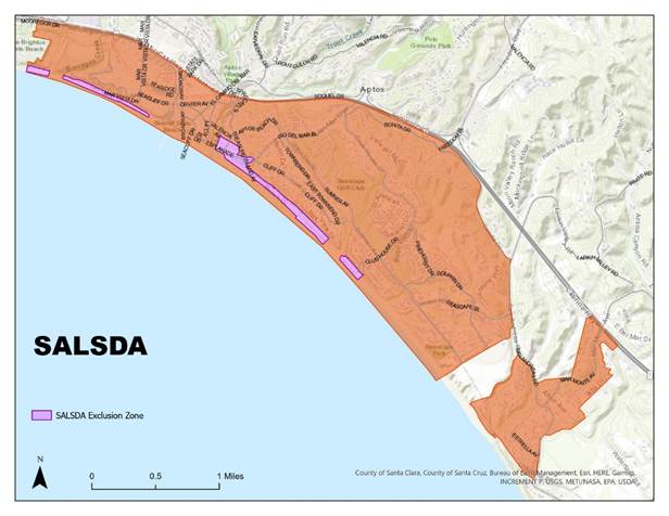
The Seacliff/Aptos/La Selva Beach Designated Area (SALSDA)
“Sea Cliff/Aptos/La Selva designated area” or “SALSDA” means that portion of the Aptos Planning Area bounded on the west by the Capitola city limit, on the north by Highway 1, and on the east and southeast by Bonita Drive, San Andreas Road, the Urban Services Line from San Andreas Road to Monterey Bay, and the community of La Selva Beach.
Short-term rentals in the following areas and streets shall not be limited by, or count toward, SALSDA caps or block density limits: Pot Belly Beach Road; Las Olas Drive; those residentially zoned parcels in the Rio Del Mar flats consisting of parcels fronting on Stephen Road, Marina Avenue, and Venetian Road between its intersection with the Esplanade and Aptos Beach Drive to its intersection with Lake Court and Stephen Road; those parcels fronting on or gaining access from Cliff Court or fronting on or gaining access from Rio Del Mar Boulevard between its intersection with Aptos Beach Drive and Beach Drive to its intersection with Kingsbury Drive, Cliff Drive, and Beach Villa Lane; Beach Drive; and Via Gaviota.
Outside of the Designated Areas
Any areas within the unincorporated county that are outside of the Designated Areas
County-Wide Limits
The number of Short-term Rental Permits within the county is subject to a maximum number in “Designated Areas” and in the “County” as a whole. See table below. To determine whether there are available permits in your area, email vacation.eplanreview@santacruzcountyca.gov.
|
Maximum Number of Short-Term Rentals
|
|
|
Non-Hosted Rentals
|
Hosted Rentals
|
|
DASDA
|
3
|
4
|
|
LODA
|
262
|
18
|
|
SALSDA
|
147
|
45
|
|
OUTSIDE DESIGNATED AREAS
|
270
|
185
|